How to Navigate with a Sextant: Celestial Navigation Basics
A sextant navigation fix is the act of measuring the angle between a celestial body — usually the sun, sometimes the moon, planets, or one of 57 selected navigational stars — and the visible horizon, then using that angle plus precise time to calculate your position on Earth. With a properly adjusted sextant, an accurate watch, and a current Nautical Almanac, a competent navigator can fix their position to within 2 to 3 nautical miles anywhere on the open ocean. No satellites, no batteries, no signal.
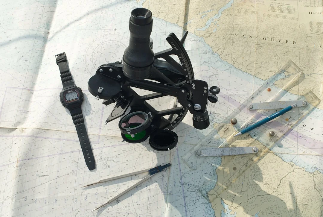
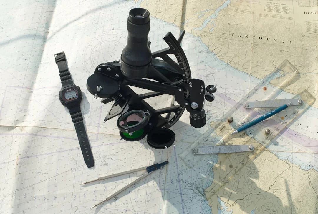
Photo by stephan hinni on Unsplash
What a Sextant Actually Measures
A sextant does one thing very well: it measures the angle between two objects. In celestial navigation, those two objects are a body in the sky (the sun, a star, the moon, a planet) and the sea horizon directly below it. That angle — called sextant altitude or Hs — is the foundation of every fix you take.
The reason this works is geometric. At any instant, every celestial body is directly overhead one specific point on Earth's surface — its geographical position or GP. If you know the body's GP from the almanac (which lists the GP at every second of the year for the sun, moon, planets, and 57 selected stars), and you measure how far above your horizon the body sits, you've measured the angular distance from yourself to that GP. Subtract from 90° and you have your zenith distance — the great-circle distance from you to the GP, expressed in degrees. One degree of arc on the Earth's surface equals 60 nautical miles, so the math becomes useful very quickly.
A single sight gives you a line of position (LOP) — strictly a circle around the GP, but in practical sailing distances the curve is so gentle that we draw it as a straight line on the chart. Two LOPs from two different bodies give you a fix. Three is better, because it tells you whether you've made an error.
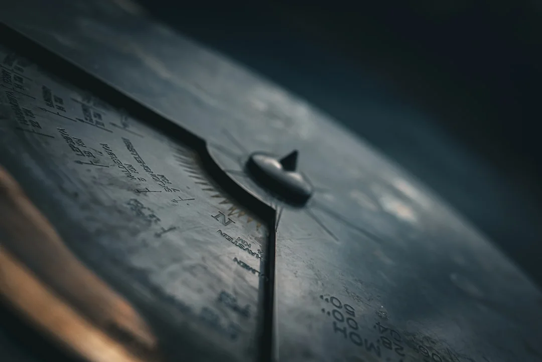
The Instrument — Anatomy of a Sextant
A modern marine sextant has not changed meaningfully since the 19th century. The main parts:
| Part | What it does |
|---|---|
| Frame and arc | The 60° (or 65°) graduated arc, which lets you read up to 120° of altitude — hence "sextant," sixth of a circle. |
| Index arm | Pivots from the arc's centre, carries the index mirror, and points to the angle on the arc. |
| Index mirror | Fully silvered. Pivots with the index arm. |
| Horizon mirror | Half silvered, half clear. You see the real horizon through the clear half and the reflected celestial body in the silvered half. |
| Telescope | Brings horizon and body into a sharp magnified view, typically 4x. |
| Shades | Coloured filters that swing in front of the mirrors. Mandatory for the sun. |
| Micrometer drum | On modern sextants, fine adjustment in minutes of arc — typically reads to 0.2'. |
A decent metal sextant from Astra, Cassens & Plath, or a vintage Tamaya costs $700–$2,000. Plastic Davis Mark 15 or Mark 25 sextants cost $200–$280 and are perfectly adequate for the noon sun and emergency use, though they drift slightly with temperature changes. Don't buy a brass display sextant — they're decoration, not instruments.
How to Take a Sight — Step by Step
Sights are taken from the cockpit or the side deck, holding the sextant in the right hand, working out from the frame so it doesn't fog with breath. The whole sequence takes about 30 seconds once you know it.
- Set the index arm to 0° and clamp it. Look at the horizon through the telescope. You should see a single, level horizon. If it's offset, your sextant has an index error — note it; you'll subtract or add it from every reading. Acceptable index error is under 3'; if it's more, adjust the horizon mirror screws.
- Pre-set the rough altitude. For the sun at midday in temperate latitudes, that's somewhere between 30° and 70°. Set the index arm to your estimated altitude.
- Swing the shades into position over the index mirror. Looking straight at the unfiltered sun through a sextant will permanently damage your eyes — this is non-negotiable.
- Bring the body down to the horizon. Point the sextant at the horizon directly below the sun, then loosen the index arm clamp and tilt the index arm until the reflected sun appears in the half-silvered mirror.
- "Rock the sextant." Tilt the instrument gently left and right around the line of sight. The reflected sun will trace an arc. The lowest point of that arc — where it just kisses the horizon — is the true altitude.
- Pinch the moment. Use the micrometer drum to settle the sun's lower limb (the bottom edge of the disc) tangent to the horizon. At that exact moment, call "mark" to your timer. Your timer notes the GMT/UT to the second.
- Read the angle. Read degrees off the arc, minutes and tenths off the micrometer drum. Write down: time (UT), Hs (sextant altitude), and which limb you used.
That is one sight. For a strong fix, take three sights of the same body within 5–10 minutes, then plot the average time against the average altitude.
From Angle to Position — Sight Reduction
Sight reduction is the math that converts your sextant altitude into a line of position on the chart. There are three common methods:
- HO 249 (Sight Reduction Tables for Air Navigation) — pre-computed tables. The fastest method by hand, around 5–7 minutes per sight. The standard for pre-GPS commercial use.
- HO 229 / NP 401 — more precise tables, slower, used when accuracy below 1' matters.
- Calculator or app — Celesticomp, BlueWater, or any of half a dozen iPhone apps will reduce a sight in seconds. Many traditionalists carry a programmable scientific calculator with the sight-reduction formula stored, as a battery-powered backup that doesn't need a phone.
The output of sight reduction is two numbers: an intercept (in nautical miles toward or away from the celestial body's GP) and an azimuth (the bearing from your assumed position to the GP). You plot from your assumed position along the azimuth line, mark the intercept distance, then draw a line perpendicular to the azimuth at that point — that's your line of position. You're somewhere on that line.
The Noon Sight — Where Everyone Starts
The single easiest sextant sight in the world is the noon sun — the moment the sun crosses your local meridian and reaches its highest point in the sky. At that instant, the math collapses into something a beginner can do in their head:
Your latitude = 90° − maximum altitude + sun's declination
That's it. No sight reduction tables, no assumed positions, no intercepts. Just the highest reading of the day and a number from the almanac.
The procedure:
- About 15 minutes before estimated local apparent noon (LAN), start taking sights every 2–3 minutes.
- Watch the altitude climb, peak, and start falling. The peak value is Ho (after applying corrections for index error, dip, refraction, and semi-diameter).
- Note the UT at peak — that gives your longitude by comparing the time to the time of meridian passage at Greenwich (the almanac lists this for every day).
- Apply the formula above for latitude.
A noon sight gets you a full position fix — both latitude and longitude — from one body. That's why every sailing school teaches it first, and why every offshore sailor practices it before they leave port. On a 14-to-18-day passage like the 1,820-nautical-mile run from Bermuda to the Azores, a daily noon sight is the rhythm that anchors the watch schedule.
You can sanity-check the latitude against your DR position: if the noon sight gives 38° 12' N but your dead reckoning says 38° 35' N, something is off — either the sight is bad or the DR is. Usually it's the DR. Usually a current set you didn't plan for.
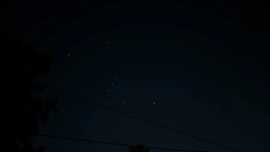
Star Sights and the Twilight Window
Star sights are how you get a real fix from celestial navigation — multiple bodies in different parts of the sky, three or four lines of position crossing in a tiny triangle. They're harder than the noon sun for one reason: timing.
Stars are only useful during nautical twilight — the roughly 25-minute window each morning and evening when the stars are visible to the eye but the horizon is still sharp enough to measure against. Too early and you can't see the stars; too late and the horizon is gone. The almanac lists civil and nautical twilight times for every latitude. Plan to be on deck with the sextant 10 minutes before nautical twilight starts.
The trick to star sights is pre-computation. Before twilight, work out which 4–6 stars will be at usable altitudes (15° to 75°) and at azimuths spread around the compass — three stars with bearings 120° apart give the strongest geometry. Set your sextant to each star's expected altitude in advance. When the star pops into view, point the sextant on its bearing, look through the telescope, and the star is already roughly in the field. You then just settle the body to the horizon and call "mark."
Six well-chosen stars in 15 minutes gives a fix accurate to 1–2 nautical miles. That is the gold standard of pre-GPS oceanic navigation, and it is still the standard a navigator is judged against on a delivery or a passage.

Photo by Vidar Nordli-Mathisen on Unsplash
What You Actually Need to Start
The minimum kit for usable celestial navigation:
| Item | Cost (approximate) | Notes |
|---|---|---|
| Plastic sextant (Davis Mk 15) | $200 | Fine for learning and for the lifeboat. |
| Metal sextant | $700–$2,000 | Lifetime instrument if cared for. |
| Quartz watch with seconds display | $30 | Set to UT. Compare to time signal weekly. |
| Current year's Nautical Almanac | $30 | Reissued every November for the next year. |
| Sight reduction tables (HO 249) | $50 (3 vols) | Or HO 229. Some sailors use a calculator. |
| Plotting sheet pad | $15 | Universal plotting sheets (Maptech). |
| Plotter, dividers, pencils | $40 | Same tools you use with a paper chart. |
Books worth the money: Mary Blewitt's Celestial Navigation for Yachtsmen (clearest 100 pages on the subject), Tom Cunliffe's Celestial Navigation, and Bowditch (free PDF from NGA). The Royal Yachting Association and US Sailing both run shore-based courses; expect to pay $250–$450 for a 3-day intensive that gets you to noon-sight competence.
For practice, you don't need an ocean. A clear horizon over a lake or even a long beach works for sun sights. Many sailors learn at home by taking artificial-horizon sights using a tray of motor oil — the oil reflects the sun's image, and you measure the angle between the sun and its reflection, then halve it. It's a real skill builder before the first ocean passage.
Photo by Alien eyes on Unsplash
Why Bother in the GPS Era
Two reasons, both unsentimental.
The first is redundancy. GPS depends on a fragile chain — antenna, cable, plotter, instrument power, satellite signal, the satellites themselves. Any one of those can fail. A lightning strike fries the whole electronics suite. A flooded chart-table corrodes connectors. A jammed signal — increasingly common in some parts of the world — turns the screen into a polite suggestion. With a sextant, an almanac, a watch, and the math, you have a parallel system that depends on the sun and the stars. Those two have a strong track record.
The second is judgement. Reading a position off a screen is not the same as understanding where you are. Sailors who can take a sight, plot it, and reconcile it with their dead reckoning develop an internal model of the boat's progress that GPS-only sailors rarely build. That model is what tells you, at 03:00 in mid-Atlantic with the wind shifting, whether your ETA is plausible — before the screen confirms it.
Many ocean-rally rules — the ARC, the Pacific Cup — recommend or require celestial-capable navigation as a backup. Insurance underwriters for Category 0/1 offshore racing often expect it. You don't need to fix to the second decimal place, but you do need to know your latitude within 5 nautical miles when the lights go out.
A position fix from celestial navigation also requires you to read the chart you're plotting on. If you're brushing up on chart skills alongside sextant work, our companion guide on how to read nautical charts covers symbols, depths, and the conventions you'll plot LOPs against. And whether you're using a sextant or a chartplotter, you can verify the distance between any two ports with Breezada's sea distance calculator and cross-check against your DR.
Frequently Asked Questions
How accurate is sextant navigation in practice?
A practiced navigator with a metal sextant and good conditions will fix to 2–3 nautical miles from a star round (4–6 sights) and 3–5 miles from a noon sight alone. Plastic sextants typically add 1–2 miles of error from frame flex and temperature drift. The biggest variable is sea state — measuring a horizon from a 35-foot boat in 3-metre swells is much harder than from a tanker bridge, and accuracy degrades accordingly. For passage planning purposes, "within 5 nm" is the realistic standard for amateur celestial.
How long does it take to learn celestial navigation?
A weekend course covers the noon sun and gets most students to a usable latitude fix. Star sights and intercept-method sight reduction need another 2–3 weeks of practice. Full proficiency — being able to fix in any conditions, recover from mistakes, and plot in your sleep — takes a season of regular use. The math is simpler than most sailors fear; the muscle memory of taking a clean sight on a moving deck is the part that needs the hours.
Do I really need a sextant if I have GPS, AIS and a chartplotter?
For coastal sailing, no. For an ocean passage of more than three or four days from land, yes — as backup, not primary. Electronics fail at sea more often than people expect, and a working celestial system is the difference between an inconvenience and an emergency. Planning a long passage with realistic distance estimates and a celestial backup is what experienced offshore sailors do as routine, not heroics; you can calculate the route distance between any two ports before you decide whether the leg is one you'd want without GPS.
What is the difference between a marine sextant and a bubble sextant?
A marine sextant uses the sea horizon as its reference — accurate to a fraction of a minute when the horizon is sharp. A bubble sextant uses an artificial horizon (a spirit-level bubble) so it can be used from an aircraft or a submarine where there's no visible horizon. Bubble sextants are roughly 5–10 times less accurate than marine sextants — useful for aviation in their day, not for marine fixes. If you're buying for a sailboat, you want a marine sextant.
Can I learn celestial navigation from an app or YouTube alone?
Partially. The math and the theory are fine to learn from video — there are excellent free courses on YouTube and on Udemy. The sight-taking technique, however, only sticks with a real sextant in your hands and a real horizon to measure against. Plan to combine self-study with at least one weekend of supervised practice, ideally on a boat. Apps like Celestial Navigation Trainer and StarPilot are excellent for sight reduction practice once you have a sight to reduce.
About the Author
Related Articles

When to Reef: Safe Systems for Simple Cruising
Learn when to reef with safe, simple systems for cruising. Reduce heel, stay in control, and sail smarter—read the guide and reef with confidence.
By Breezada Team

Sailing in Greece: Cyclades, Ionian & Dodecanese
Plan sailing in Greece across the Cyclades, Ionian & Dodecanese. Get routes, tips and best times—read now and start your charter!
By Breezada Team
VHF Marine Radio Channels: DSC Setup & Call Scripts
Learn VHF marine radio channels, DSC setup, and call scripts to stay safe on the water. Read the guide and upgrade your radio skills today.
By Breezada Team

Greece Sailing Itinerary: 7 & 14 Days by Region
Plan the perfect Greece sailing itinerary with 7- and 14-day routes by region. Get tips and start mapping your trip today!
By Breezada Team